
A History of Mogadore Reservoir and Dam
located in Suffield, Brimfield, and Mogadore, Ohio 1936-1939
Presented by Brian Ebie
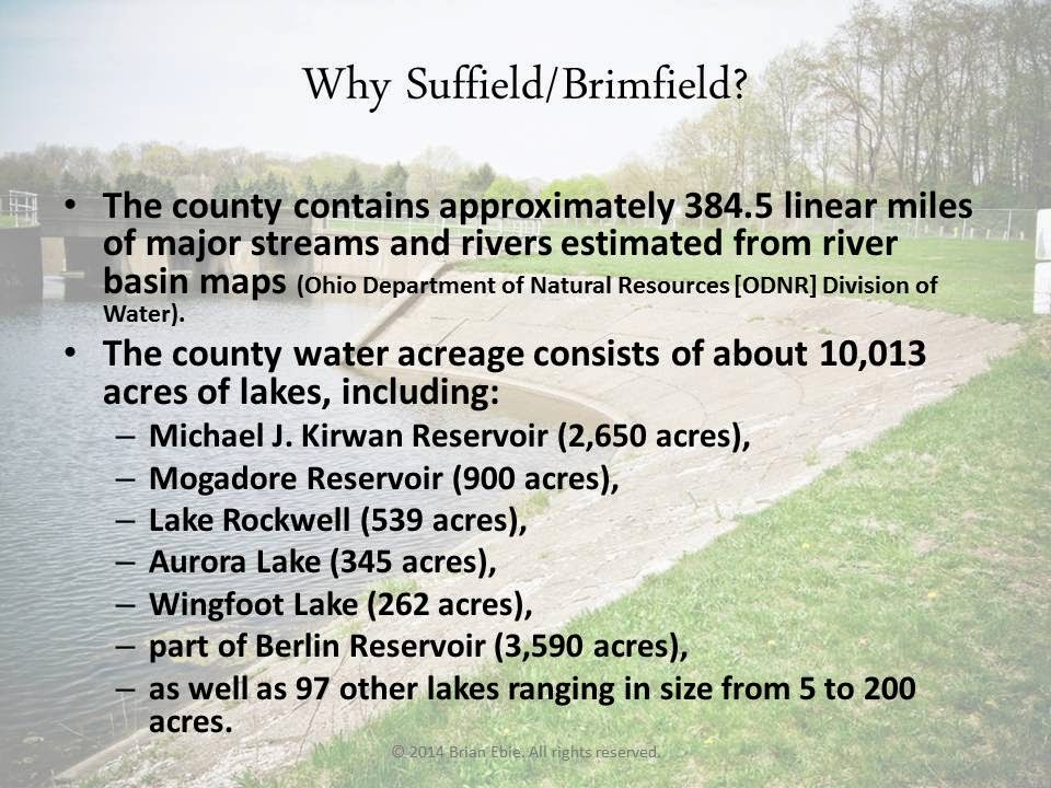
In 2010, I was approached by the Suffield, Ohio Historical Society to create a presentation on the History of the Mogadore Dam and Reservoir in Northeast Ohio which was built by the Works Progress Administration during the years 1936-1939. With some 19 miles of shoreline, this beautiful lake is a home to many varieties of panfish, bass, catfish, carp, and other fish; wildlife; an attraction for game fishing and boating, kayaking, and canoeing. Surrounding the lake shores are numerous trails for hiking where the woods are populated with majestic oaks, maples, poplars, various conifers and countless species of plants. People fish year round, and when the winters are cold enough they even ice-fish on the reservoir. During every season of the year the surrounding shores are beautiful with spring flowers, autumn leaves, and snow on tree branches.
Having lived around the reservoir all my life, I was excited to learn more about it's origins. I knew my grandfather worked as a security guard for the WPA when the dam was built, and had heard stories of the land before it was flooded, but this challenge from the historical society propelled me to look deeper. I knew the water was originally to be used for cooling industrial machinery in the plants at Goodyear and other manufacturers in Akron.
After many hours spent in the Akron Public Library, the University of Akron Archives, the City of Akron Water Department, in email exchanges with the United States Department of the Interior, and through conducting interviews with area residents alive during those years of construction, I was able to gather a great deal of information on the history and challenges of building the reservoir. Subsequently, I created a PowerPoint presentation that I shared with several historical societies, civic organizations, and even church groups. The presentation, "Before the Flood: From Farming to Fishing on the Mogadore Reservoir" was a hit.
Following is the body of my presentation, optimized for a blog format. I hope you find it informative and interesting.

 |
| Mogadore Dam in Autumn. A beautiful place. |

.JPG)
The lake on Jacob Roth's former land, still called Roth Lake.

Some of the other names for the stream that feeds the Mogadore Reservoir. Fox Ditch is on Martin Road, Little Cuyahoga runs through Mogadore and on to Akron.

Hill's Pond runs from just beyond Martin Road, west to Rt 532 and on into the Little Cuyahoga.


The process of taking land from farmers and homeowners became very litigious. Akron officials were adamant that they were taking the land, often paying well below the value of the property. They forced people into court, took land by imminent domain, and fought Portage county at every opportunity. Residents and farmers lost every battle.
This article sort of sums it up, especially these words: "we're not going to play Santa Claus on this thing" and "Ninety per cent of the land we want isn't being used at the present time."

Here are the planners of the project, Kemmler, Paul, Knappen, LaDue (Akron Water Works Superintendent), Bessell, Barbour (architect), Holl, McGill.


Look at the first clipping below. The WPA workers showed up for work, but there were no shovels, picks, nothing.
Look at the second clipping. Here is where the City of Akron was going to try to condemn the land for State Route 43, and reroute it down Congress Lake Road.

More articles regarding parcels of land being purchased by the City of Akron. Of most interest is the third article down on the right. P.W. Litchfield, President of Goodyear Tire & Rubber, now comes out and says that Goodyear doesn't need the water to cool their tire making machinery--the entire reason it was built!!

Here, Benjamin Lepper wouldn't agree to a price for his 30 acres, so the City of Akron started condemnation proceedings against him in court.

In this article, Mrs. Mary Minch is watching her childhood home, already 100 years old in 1937, be knocked down to make way for the dam.

An article describing the important work of testing the soil.

In a last ditch effort, Portage County took Akron to court to stop them from flooding over Ohio 43 and relocating it to Congress Lake Road. It would be one of the only "wins" for the county. The small bridge we drive over every day was the result of this action.

Here's a modern photo of the bridge on Ohio 43 in Suffield.

Another road affected by the building of the reservoir was Brimfield Township Highway 79, called Saxe Road. Saxe road originally ran from Route 532 in Mogadore, all the way to Randolph. It is now divided into three sections. Following are pictures of Saxe road's dead ends.


A neat aerial photo of the dam and west dike, making headlines in the Akron Beacon Journal.

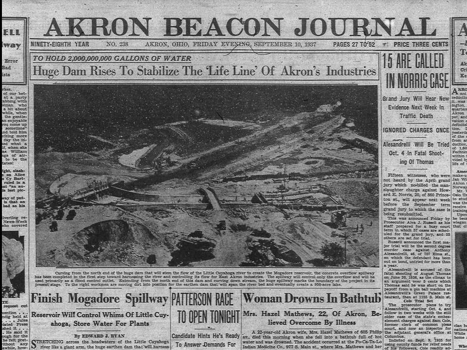
Here, I've cropped out the article and you will see the original aireal view followed by a modern picture from Google Earth.


In the following pictures it will be shown that a great deal of work was done by hand. Men with shovels and picks and block & tackle rigs. This was hard work, and it was work for people when the economy was struggling. These were truly "shovel-ready" jobs.


I think this is a very cool shot of the retaining wall being built, just starting to clear the spillway at the Dam site, followed by a picture from today.


Here are the details of the Dam and Dikes, along with photographs of each area.


Here is another Google Earth view of the Dam, Spillway, and the little building that houses the controls for the water flow, followed by modern photographs of the area. The original documents from the planning of the Dam were very specific, even to the colors of the paint inside the building. All very 30's issue government colors... Olive drab wainscoting, tan walls, black trim.


Sunset on the Mogadore Reservoir. Today, the reservoir still provides flood protection for Akron and it's waters are still released into the Little Cuyahoga at around four million gallons per day. It is a beautiful place for recreation, boating, fishing, picnics, and to photograph. Despite the controversy surrounding it's construction and use originally, it remains something beautiful to behold and stands as a testament to hard-working men who dug it by hand.

All content and photographs Copyright 2014 by Brian Ebie. All rights reserved. Reproduction prohibited without author consent.
No comments:
Post a Comment